
Lee Grenci, 2:57 PM GMT on February 19, 2013
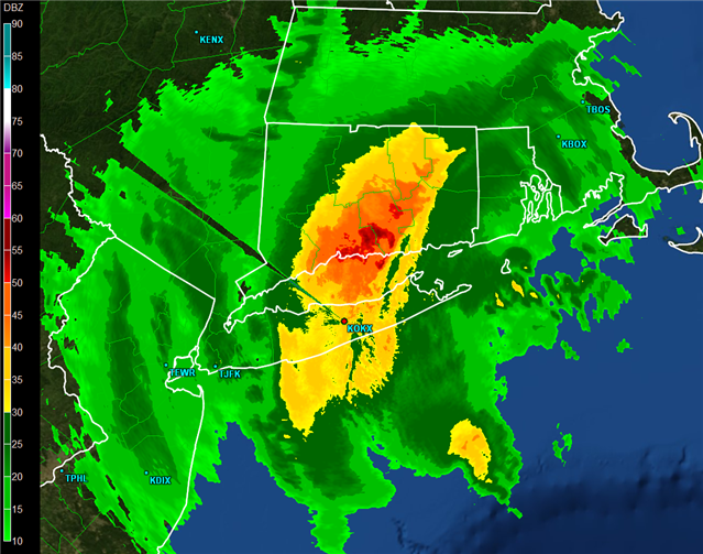
The 0218Z image of base reflectivity from the radar at New York City / Upton, NY (KOKX) on February 9, 2013 (the evening of February 8). Larger image. The 50+ dBZ reflectivity of snow is the highest I've observed in my 40 years of forecasting.
Of course, I've seen high reflectivities associated with bright bands (wet snow near the top of a melting layer; stay tuned), so I'm referring exclusively to high reflectivities associated with snow that reaches the ground. Before I discuss Nemo and the storm features that led to such high reflectivities over Connecticut on the evening of February 8, 2013, I think a slight digression on bright banding is in order (I've heard too many erroneous explanations for relatively high reflectivity in wintry situations that never even consider bright banding as a possible cause). For the record, bright banding was discovered during military operations in World War II, and there were papers written in the 1940s that explained the underpinning science (example 1946 paper).
Here's how I explain bright banding. As falling snowflakes reach the top of the melting layer, where the temperature is 0 degrees Celsius, they began to melt (again, 0 degrees Celsius = 32 degrees Fahrenheit is NOT the "freezing mark"). Melting snowflakes soon become covered with a film of meltwater, and they look like large raindrops to the radar. Thus, the base reflectivity abruptly (and dramatically) increases. In rather quick fashion, however, snowflakes melt completely, shriveling in size as raindrops take shape. Since radar is very sensitive to particle size, reflectivity decreases rapidly once the melting process is complete. Moreover, raindrops now quickly accelerate earthward (raindrops fall faster than snowflakes). This rather abrupt acceleration after the water-covered snowflakes melt completely into raindrops decreases the number of radar targets just below the melting level (like the flow of traffic quickly opening up after cars accelerate away from a crowded toll booth on a super-highway). The combined effect of decreasing both the size and number of drops causes radar reflectivity to decrease just below the melting layer, creating a band of higher reflectivity (a bright band) above the ground.
For more information on this story click here.