Showers to return across the UK, with only 1.8in of rain needed before 31 December to make 2012 wettest on record
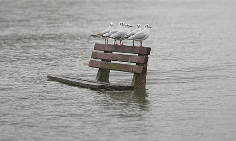
Gulls perch on a flooded park bench in Pangbourne. Flood warnings remain in place in England and Wales. Photograph: Oli Scarff/Getty Images
Flood warnings remain in place for England and Wales as the respite from heavy rain is expected to give way to another band of miserable weather today on Sunday.
Strong winds and showers followed by more heavy downpours will bring the last weekend of 2012 to a wet end.
The year of 2012 is fast running out, and with it, the anticipation of what is coming is building. As we have already touched upon, this can in many ways be likened to not only the starting of a new year, but actually the starting of a new era. For what you have accomplished in these last few weeks, far surpasses anything you have ever been through, and as such, you will all be well armed to take up the challenge of continuing to build your new world.
A trio of sledders make their way down the side of a hill at Fort Harrison State Park, Thursday, Dec. 27, 2012 in Indianapolis. Several sledders enjoyed the hill after the area received 7.5 inches of snow. (Associated Press)
LITTLE ROCK, Ark. -- A cold rain fell across Arkansas on Friday, washing away some of the Christmas Day ice and snow that knocked out power to 194,000 customers - including businesses that rely on post-holiday sales - of the state's largest electric utility.
"Euclid was a remarkable, widespread storm system," says weather.com meteorologist Chris Dolce. "A swath of snow fell all the way from California's Sierra Nevada Mountains to parts of the South, Ohio Valley and Northeast. At the same time, the storm spawned a record number of tornadoes for Christmas Day in the South. The combination made for plenty of travel headaches for millions during the busy Christmas holiday week."
A Pennsylvania Department of Transportation snowplow driver clears Lakeside Drive at Harveys Lake, Pa., Saturday, Dec. 29, 2012.(Associated Press)
NEW YORK -- Winter Storm Freyr dumped up to a foot of snow in parts of southern New England and parts of Ohio on Saturday, just days after the regions were hit by Winter Storm Euclid moving from the nation's midsection.
The storm had ended in the region by Sunday morning and dry weather was expected for days, although strong winds may chill the bone.
To read the rest of this story, visit Weather.com.
Kristina Waymire, 13, of Baltimore builds a snowman along the shoulder of Interstate 83 while waiting in stopped traffic for an hour and a half following a 14-vehicle wreck in York, Pa. on Saturday, Dec. 29, 2012. (Associated Press)
Winter Storm Freyr delivered a swath of snow from the Ohio Valley Friday night eastward across the Northeast on Saturday into early Sunday.
Origin of the name Freyr (rhymes with "flare") - A Norse god associated with fair weather, among other things.
To watch the video and read the rest of this story, visit Weather.com.
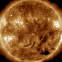
December 30, 2012 – SPACE – SOLAR CYCLE UPDATE: 2013 is only days away, and according to most forecasters, Solar Max should be approaching as well. But is it? Barely-increasing sunspot counts and anemic solar activity suggest an interesting possibility: Perhaps Solar Max is already here. (Below) This plot of measured vs. predicted sunspot numbers illustrates the idea: The blue curve traces monthly sunspot numbers measured since 2000.
The red curve is the prediction of the NOAA-led Solar Cycle Prediction Panel. So far, Solar Cycle 24 is underperforming even compared to the panel’s low expectations. There is still a strong chance that Cycle 24 will rebound and peak in 2013 as expected. It might even be a double-peaked cycle like the cycle before it. As 2013 nears only one thing is certain: we don’t know what will happen. Stay tuned. –Space Weather