Alaska

Very strong earthquake M7.0 struck south of Atka, Alaska

Silver's picture

Thewatchers.adorraeli.com, By: Adonai, 08/30/2013

A very strong earthquake with recorded magnitude of 7.0 (USGS) struck south of Atka, Alaska on August 30, 2013 at 16:25 UTC. Preliminary reports placed depth at 34.5 km (21.4 miles). EMSC is also reporting M7.0 earthquake and depth of 40 km. Epicenter was located at sea, 91 km (57 miles) SW of Atka, Alaska and 1509 km (938 miles) SSE of Anadyr', Russia. Earthquake struck below Andreanof Islands on Aleutian Trench. No tsunami is expected.


For more on that story visit www.thewatchers.adorraeli.com

Alaska’s forest fires burn more fiercely

Magikalspirit's picture

Climate News Network- Tim Radford, July 26,2013

Fireweed dominates a scene once covered in black spruce in Alaska's Yukon Flats Image courtesy of Feng Sheng Hu of the University of Illinois at Urbana-Champaign

Magenta-flowered fireweed dominates a scene once covered in black spruce Alaska’s Yukon Flats
Image courtesy of Feng Sheng Hu of the University of Illinois at Urbana-Champaign

Some recent fires in the forests of Alaska have been the worst for 10,000 years, researchers say – and they could happen elsewhere in this warming world.

LONDON, 26 July – There have always been fires in the cold forests of Alaska. Periods of burning are part of the ecological regime, and fires return to black spruce stands of the Yukon Flats at intervals of tens to hundreds of years.

But recent evidence suggests that fire is about to come back with a vengeance – or, in the language of science, “a transition to a unique regime of unprecedented fire activity”.

Read More:

Veniaminof volcano (Alaska Peninsula, USA) activity update

Magikalspirit's picture

Volcanodiscovery-June 17,2013

Photo of Veniaminof on 13 June, taken from Port Moller by Bob Murphy (via AVO)

The eruption continues at low levels. Recent satellite images show very high elevated surface temperatures at the intracaldera cinder cone consistent with continued effusion of lava. No plumes have been observed in satellite images nor reported by pilots or local observers. (AVO)

Read More: http://www.volcanodiscovery.com/veniaminof/news.html

Veniaminof volcano (Alaska Peninsula, USA) activity update

Magikalspirit's picture

Volcanodiscovery-June 12,2013

ASTER (Advanced Spaceborne Thermal Emission and Reflection Radiometer) satellite image showing a steam plume emitting from the active intracaldera cone at Veniaminof Volcano on March 4, 2008 at 12:57 PM AKS (image processed by AVO/USGS, Image data courtesy of NASA/GSFC/METI/ERSDAC/JAROS, and U.S./Japan ASTER Science Team)


Seismic tremor continued to slowly but steadily increase yesterday, then dropped temporarily and has been increasing again today. AVO reports an intermittent, low-level steam plume issuing from the central cone within the caldera. No elevated surface temperature were visible in satellite images. No other activity was confirmed by AVO.


Read More: http://www.volcanodiscovery.com/alaska.html

Mount Veniaminof volcano erupts in Alaska

Magikalspirit's picture

The Extinction Protocol -June11,20113


A weak eruptive activity has started from the volcano. Since last night, weak ash emissions have appeared from the central cone of the caldera of the volcano. The new activity is accompanied by a persistent steam plume and increasing volcanic tremor. So far there seem to be no lava flows or other significant eruptive processes. The new ash emissions are very diluted and reach about 200-300 m height. They were first observed on the Aviation camera of Perryville from last night at around 17-18h local time. AVO who has not yet reported about the ash confirmed to Blog Culture Volcan that the plume indeed contains very small amounts of ash, which pose no problems to aviation (for now). The volcano last erupted in 2008. –Volcano Discovery


Read More: http://theextinctionprotocol.wordpress.com/2013/06/11/61-mount-veniaminof-volcano-erupts-in-alaska/


Pavlov volcano (Alaska Peninsula, USA) activity update

Magikalspirit's picture


VolcanoDiscovery-June 8,2013


MODIS hot spot data (past 7 days) for Paluweh volcano (ModVolc, Univ. Hawaii)

MODIS hot spot data (past 7 days) for Paluweh volcano (ModVolc, Univ. Hawaii)


Weak eruptive activity continues, producing small steam and ash plumes drifting at about 18-20,000 ft (5-6 km) altitude SSE as detected on satellite data (VAAC Anchorage).


Read More: http://www.volcanodiscovery.com/pavlov/news.html

Alaskan Bears Assist With Cleanup in Flood Stricken Town

Desert Gypsy's picture

Weather.com - 6/4/13, Associated Press


GALENA, Alaska -- Yukon River flooding that knocked out power to the Alaska village of Galena has brought on a number of secondary problems, including how to keep bears away from hundreds of pounds of game meat that has spoiled in residents' refrigerators and freezers.
 
The flood caused by ice clogging the Yukon submerged some homes and washed out the road to the community's landfill. On Monday, emergency responders were developing plans to collect spoiled meat and fly it by helicopter to the dump, said Jeremy Zidek, spokesman for the Alaska Department of Military and Veterans Affairs.
 
For more on this story please see Weather.com


New volcanoes in Alaska discovered

Magikalspirit's picture


TheCelebrityCafe.com-Emma Tremblay-June 3,2013


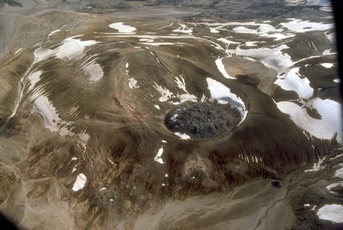
Given their tendency to erupt, spewing out tons of molten lava and ash, it seems all the volcanoes in the world should have been discovered, cataloged, and researched by now. But in the past three years, U.S. Geological Survey geologists have discovered twelve new volcanoes in the southeastern region of Alaska, similar to the one pictured below.

The intrigue began in 2009, reports Live Science, when scientists discovered a volcano which erupted around the same time as Mt. Edgecumbe (the panhandle’s biggest volcano) that had a completely different chemical signature from its neighbor. With increased expeditions to the volcano came even more volcanic discoveries, all with a chemical pattern that turned out to be identical to that of the Northern Cordilleran Volcanic Province, a field of volcanoes in Canada already known to be 1,250 miles long and 375 miles wide. Those dimensions may now have to be revised.


Read More: http://thecelebritycafe.com/feature/2013/06/new-volcanoes-alaska-discovered

A Blast of a Find: 12 New Alaskan Volcanoes

Magikalspirit's picture


Beck Oskin, OurAmazingPlanet Saff Writer-May 31 2013


One of the newest volcanic vents discovered in Southeast Alaska is an underwater volcanic cone in Behm Canal near New Eddystone rock.
CREDIT: James Baichtal, U.S. Forest Service


In Alaska, scores of volcanoes and strange lava flows have escaped scrutiny for decades, shrouded by lush forests and hidden under bobbing coastlines.

In the past three years, 12 new volcanoes have been discovered in Southeast Alaska, and 25 known volcanic vents and lava flows re-evaluated, thanks to dogged work by geologists with the U.S. Geological Survey (USGS) and the U.S. Forest Service. Sprinkled across hundreds of islands and fjords, most of the volcanic piles are tiny cones compared to the super-duper stratovolcanoes that parade off to the west, in the Aleutian Range.

Pages

Subscribe to RSS - Alaska