cyclone

Tropical Cyclone Zane heading to Cape York Peninsula

Silver's picture

Weatherzone, By: Rob Sharpe, 04/30/2013


Zane should be the first tropical cyclone in seven years to cross Queensland's Cape York Peninsula, likely reaching category three. Tropical Cyclone Zane formed off the Queensland coast on Tuesday morning as it quickly developed and sped westwards. The cyclone will move west-northwest and should cross the coast between Orford Ness and Lockhart River late on Wednesday as a category two or three cyclone.


The last time a tropical cyclone crossed the Peninsula was in April 2006 when Severe Tropical Cyclone Monica crossed just south of Lockhart River as a category three system.


For more on this story visit www.weathezone.com

Possible late season cyclone for Queensland

Silver's picture

Weatherzone, By: Drew Casper-Richardson, 04/27/2013


The north tropical Queensland coast may be impacted by a late season tropical cyclone next week. A weak low has formed within a trough over the Solomon Sea. Over the next few days this low is expected to intensify and move slowly in a west-southwest direction, towards the eastern Cape York Peninsula coast. The Bureau of Meteorology are rating Monday as a high likelihood (that is, greater than 50% chance) of this system developing into a tropical cyclone.


Should a cyclone form it will be named Zane. Sea surface temperatures in the region are around 29 degrees which provides ample energy to fuel tropical cyclone formation and development.


For more on this story visit www.weatherzone.com

Cyclone-prone community gets weather radar

Silver's picture

Weatherzone, By: Matt Brann, 04/22/2013


The Bureau of Meteorology has installed a weather radar in the remote community of Warruwi on South Goulburn Island in the Northern Territory. Situated off the coast of Arnhem Land, the Goulburn Islands are a real hot spot for cyclones, and were severely damaged by Cyclone Monica in 2006.


However, the region has been a black-spot in terms of coverage and monitoring for the weather bureau - until now. Warruwi Elder, Bunug Galaminda, says the official opening has been a day of celebration for the community.


For more on this story visit www.weatherzone.com

Cyclone threatening Lord Howe Island

Angelove117's picture

Weather Zone.com - 3/14/13, Brett Dutschke


Sandra first formed late last week over the Coral Sea, about 1000km northeast of Mackay. She then intensified into a severe category three system while travelling east, further away from mainland Australia. Early this week she turned more southerly, towards Lord Howe Island but had weakened into a category one cyclone.


During this morning Sandra intensified and is likely to continue to do so during the day while closing in on Lord Howe Island. At this stage the cyclone should travel just to the east of Lord Howe while staying well to the west of Norfolk Island. By tomorrow morning the system should weaken just to the south and by tomorrow evening should weaken into a tropical depression on its way to New Zealand.


Tropical Cyclone Sandra Churns Well East of Australia

Angelove117's picture

Accuweather.com - 3/11/13, Eric Leister


Tropical Cyclone Sandra was still a very strong storm, hovering at sea northwest of New Caledonia on

Monday.While far to the east of Australia, Sandra was helping to whip up rough surf and rip currents, which will be likely to last through at least Wednesday, along some Queensland beaches.


Tropical Cyclone Haruna spinning southwest of Madagascar

Desert Gypsy's picture

thewatchers.adorraeli.com-2/21/2013, Chillymanjaro
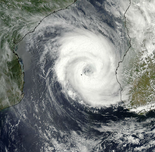


Tropical Cyclone Haruna (16S) in South Indian Ocean, is forecast to increase in intensity in the next 24 hours to a peak of 100 knots, gusting up to 125 knots. Increasing vertical wind shear and land interaction will begin to weaken the system in the next 24 hours.

According to latest report by Joint Typhoon Warning Center (JTWC), Tropical Cyclone Haruna is located approximately 380 nm southwest of Antananarivo, Madagascar, has tracked southeastward at speed of 03 knots, generating 7.6 meter-high (25-foot-high) waves. Animated infrared satellite imagery shows the system continued to deepen as it maintained a large and symmetrical 30-nm eye. Upper level analysis indicates the system is just to the west of an anticyclone in an area of low (05-10 knot) vertical wind shear and excellent radial outflow.


For more information and some great pictures on this story click here.

Pages

Subscribe to RSS - cyclone