Galactic Free Press

Tropical Cyclone Sandra Churns Well East of Australia

Angelove117's picture

Accuweather.com - 3/11/13, Eric Leister


Tropical Cyclone Sandra was still a very strong storm, hovering at sea northwest of New Caledonia on

Monday.While far to the east of Australia, Sandra was helping to whip up rough surf and rip currents, which will be likely to last through at least Wednesday, along some Queensland beaches.


Recap: Severe Weather Rattles Texas, Oklahoma

Angelove117's picture

Accuweather.com - 3/10/13, Brian Edwards


AccuWeather meteorologists monitored a zone from central Texas to southern Oklahoma for severe weather Saturday afternoon and night.


A potent storm system, also responsible fornear-blizzard conditions in the Rockies and Plains, spent Saturday afternoon through early Sunday morning generating strong thunderstorms.


For more weather details click: Severe Weather


Sprawling Nor'easter still bringing heavy snow, damaging coastal floods

Angelove117's picture

Wunderground.com - 3/8/13, Dr. Jeff Masters


It's not often that a Nor'easter centered more than 600 miles out to sea brings heavy snow and and major coastal flooding to New England, but Winter Storm Saturn is a one-of-a-kind. The massive storm, which was centered about 600 miles east-southeast of New York City at 7 am EST, sprawls out over a huge area of ocean more than 1000 miles across. While the central pressure of 988 mb is not exceptionally low for a Nor'easter, the sheer size of the storm is allowing Saturn to pile up a formidable storm surge, which hammered the coast of Eastern Massachusetts during the Friday morning high tide cycle, causing severe erosion, widespread street flooding, and damage to roads and houses.


Winter Storm Triton: Snow Aims for Denver, Plains

Angelove117's picture

Weather.com - 3/9/13, Chris Dolce


The storm dumped more than a foot of snow onFlagstaff, Ariz. Up to a foot of snow was also reported in the mountains of Southern California (Riverside County). 


Snow will continue through much of the day in the mountains of Utah, Arizona, New Mexico and Colorado. A bonus for those with spring break ski trips to the West.


Big Story Weather – March 8, 2013

Angelove117's picture

Red Orbit.com - 3/8/13, Joshua Kelly


Big Story Weather from March 7: The storm system finally began to push away from the Northeast, however, there was still some moderate snowfall in the region. High pressure brought some cold air to Florida last night with places seeing frost. The low pressure system also began to impact the Southwest US.


Weather Outlook for March 8: A few lingering snow showers will be found over the Northeastern US today, while high pressure builds in over the Great Lakes and extends southward into the Southeast and Gulf Coast region. A new low pressure system will push into the Southwest bringing heavy rains and higher elevation snows. Below is the weather for a few select cities for today.

Tropical Cyclone Sandra gained more strength and is moving toward New Caledonia

Angelove117's picture

The Watchers.com - 3/9/13, Adonai


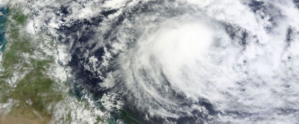
Tropical Cyclone Sandra (TC 19P) in Southern Pacific Ocean is gaining more strength. Sandra was upgraded from a Category 1 to Category 2 tropical cyclone overnight with the possibility of an upgrade to Category 3 tomorrow and Category 4 on Monday. Sandra’s central convection strengthened over the storm’s center since the previous day, which indicates that Sandra is gaining strength.


According to latest report by Joint Typhoon Warning Center (JTWC), Tropical Cyclone Sandra is located approximately 645 nm northwest of Noumea, New Caledonia, and is moving eastward at 06 knots over the past six hours. Sandra is expected to continue to move southeast, sparing Queensland’s coastline. Some swells in coastal waters are expected towards the end of next week. Residents of New Caledonia should prepare for impacts from Sandra early next week.  Sandra is expected to pass west of New Caledonia on March 12, and bring heavy rain, possible flooding, strong winds and rough surf.

Chicago Winter Has Arrived Full Force

Angelove117's picture

Accuweather.com - 3/7/13, Molly Cochran


A snowstorm dropped a record-breaking 9.2 inches of snow in Chicago on Tuesday. The old daily record breaking snowfall for March 5 was 3.8 inches and was set in 1999.


So much snow fell that travel was impacted, causing 460 arriving flights and 422 departing flights to be canceled at the O'Hare International airport. Chicago Midway International airport had 131 arriving flights canceled and 128 departing flights canceled, according to FlightAware.com.


Winter Storm Saturn: Snowfall Totals, Storm Reports

Angelove117's picture

Weather.com - 3/8/13, Nick Wiltgen


Snow hit the central and northern Rockies on Sunday, March 3, and spread into North Dakota by Monday, March 4. By Tuesday, March 5, the most significant snows had shifted into the Upper Mississippi Valley and the Great Lakes region. On March 6, snow took aim on the Appalachians and areas to the west of Washington, D.C.  Now, Saturn's snow is blanketing parts of New England and the Northeast.


For more details on this story click: Storm Saturn


Big Story Weather – March 7, 2013

Angelove117's picture

Red Orbit.com - 3/7/13, Joshua Kelly


Weather Outlook for March 7: The strong low pressure system will work its way slowly out to sea today. However, the Northeast will be dealing with the winds, storm surge and also the rain and some heavy snowfall are all possible in the region. High pressure over the Southeast will keep the region dry. The new storm system will begin to push into the Southwest today bringing showers to the region. A few showers and higher elevation snows linger over the Pacific Northwest. Below is the weather for a few select cities for today.


March 7, 2013 Storm Tracker Update:

Pages

Subscribe to RSS - Galactic Free Press