
NASA.gov -Fred Espenak, Published in Observer's Handbook: 2013, Royal Astronomical Society of Canada
In 2013, there are two solar eclipses and three lunar eclipses as follows.
| 2013 Apr 25: Partial Lunar Eclipse |
| 2013 May 10: Annular Solar Eclipse |
| 2013 May 25: Penumbral Lunar Eclipse |
| 2013 Oct 18: Penumbral Lunar Eclipse |
| 2013 Nov 03: Hybrid Solar Eclipse |
Predictions for the eclipses are summarized in Figures 1, 2, 3, 4, 5, and 6. World maps show the regions of visibility for each eclipse. The lunar eclipse diagrams also include the path of the Moon through Earth's shadows. Contact times for each principal phase are tabulated along with the magnitudes and geocentric coordinates of the Sun and Moon at greatest eclipse.
Partial Lunar Eclipse of April 25
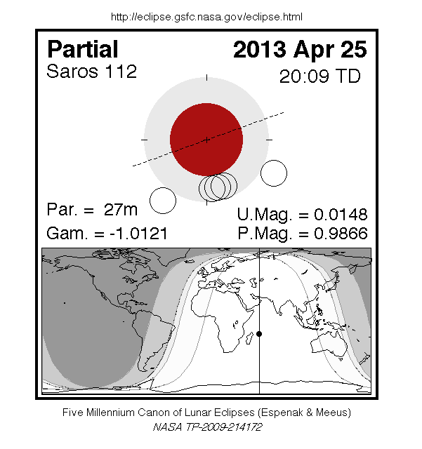
The first lunar eclipse of 2013 occurs at the Moon's ascending node in southern Virgo about 12° east of Spica (mv = +1.05). It is visible primarily from the Eastern Hemisphere. The Moon's contact times with Earth's shadows are listed below.
               Penumbral Eclipse Begins:  18:03:38 UT
               Partial Eclipse Begins:    19:54:08 UT
               Greatest Eclipse:          20:07:30 UT
               Partial Eclipse Ends:      20:21:02 UT
               Penumbral Eclipse Ends:    22:11:26 UT
At the instant of greatest eclipse[1] the umbral eclipse magnitude will reach 0.0147. This event is barely partial with just 0.5 arc-minutes of the Moon's northern limb dipping into umbral shadow. Consequently, the partial phase lasts less than 27 minutes.
Figure 1 shows the path of the Moon through the penumbra and umbra as well as a map of Earth showing the regions of eclipse visibility. To catch the entire event, one must be located in eastern Europe or Africa, central Asia or western Australia. At the instant of greatest eclipse the Moon will be at the zenith for an observer just east of Madagascar. Eastern parts of South America will experience moonrise with the eclipse already in progress, but none of the eclipse is visible from North America.
The April 25 eclipse belongs to Saros 112, a series of 72 eclipses in the following sequence: 7 penumbral, 21 partial, 15 total, 22 partial, and 7 penumbral lunar eclipses (Espenak and Meeus, 2009). In particular, the April 25 event is the last partial eclipse in Saros 112. Complete details for the series can be found at:
eclipse.gsfc.nasa.gov/LEsaros/LEsaros112.html
Annular Solar Eclipse of May 10
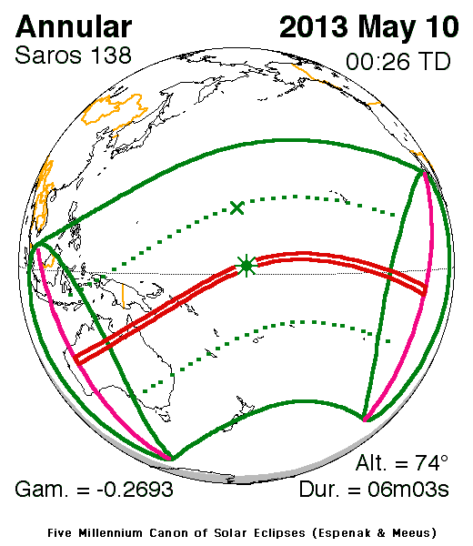
The first solar eclipse of 2013 occurs at the Moon's descending node in eastern Ares. An annular eclipse will be visible from a 171 to 225 kilometre-wide track that traverses Australia, eastern Papua New Guinea, the Solomon Islands, and the Gilbert Islands. A partial eclipse is seen within the much broader path of the Moon's penumbral shadow, which includes Australia, Indonesia, Oceania and much of the central the Pacific Ocean (Figure 2).
The annular path begins in Western Australia near Collier Range National Park at 22:33 UT. Because the Moon passes through apogee just 3 1/2 days later (May 13 at 13:32 UT), its large distance from Earth produces a wide path of annularity. Traveling northeast, the shadow quickly sweeps across the Northern Territory where Tennent Creek experiences an annular phase of 3 minutes 4 seconds. Since the eclipse occurs here shortly after sunrise, the Sun is just 16° above the horizon. On the central line 70 km to the north, annularity lasts 4 minutes 27 seconds at 22:37 UT.
The antumbral shadow crosses the Gulf of Carpentaria and reaches the Cape York Peninsula at 22:44 UT. As it does so, it crosses the track of the previous year's total solar eclipse (2012 November 13). Four minutes later, the shadow departs Australia at Lakefield National Park (22:48 UT).
The next landfall in the eclipse path occurs in eastern Papua New Guinea at 23:00 UT. The central line crosses Basilaki Island where annularity lasts 4 minutes 59 seconds with the Sun at an altitude of 39°. Traveling at 0.98 km/s, the antumbra next reaches the Solomons where Choiseul, the largest island in the chain, lies at the center of the track. Annularity is now 5 minutes 16 seconds and the Sun is 49° above the horizon (23:15 UT). This is the last major landfall in the path.
As the antumbral track curves to the east, it encounters Tarawa atoll in the Gilbert Islands (Republic of Kiribati). The duration of the annular phase reaches the 6-minute mark here at 00:15 UT. The annular ring is quite thick because the Moon appears only 95% the diameter of the Sun.
The instant of greatest eclipse [2] occurs at 00:26:20 UT when the eclipse magnitude [3] will reach 0.9544. At that instant, the duration of annularity is 6 minutes 3 seconds, the path width is 173 kilometres and the Sun is 74° above the flat horizon formed by the open ocean.
The shadow passes just north of Kiribati with no other landfall of any consequence occurring over the remainder of the track. At 02:20 UT, the antumbral leaves Earth's surface as the annular path ends.
During the course of its 3/4-hour trajectory, the antumbra's track is approximately 13,300 kilometres long and covers 0.50% of Earth's surface area. Path coordinates and central line circumstances are presented in Table 1 at five-minute intervals. The first column gives the Universal Time (UT) while the next six columns define the northern and southern limits as well as the central line coordinates at that instant. The Sun's altitude at maximum eclipse is given, followed by the width of the central path and the duration of totality.
Partial phases of the eclipse are visible primarily from Australia, New Zealand and Indonesia. Local circumstances for a number of cities are found in Table 2. All times are given in Universal Time. The Sun's altitude and azimuth, the eclipse magnitude and obscuration [4] are all given at the instant of maximum eclipse.
This is the 31st eclipse of Saros 138 [5] (Espenak and Meeus, 2006). The family began with a series of 7 partial eclipses starting on 1472 Jun 06. The first annular eclipse was on 1616 Sep 11. After a series of 50 consecutive annular eclipses, Saros 138 will produce one hybrid and three total eclipses before it terminates on 2716 Jul 11 after a final nine partial eclipses. Complete details for the 70 eclipses in the series (in the sequence of 7 partial, 50 annular, 1 hybrid, 3 total, and 9 partial) may be found at:
eclipse.gsfc.nasa.gov/SEsaros/SEsaros138.html
Penumbral Lunar Eclipse of May 25
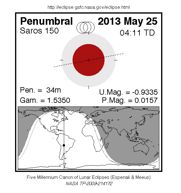
The second lunar eclipse of the year again occurs at the Moon's ascending node in Scorpius about 7° northwest of Antares (mv = +1.07). With a penumbral eclipse magnitude [6] of 0.0158, just 0.5 arc-minutes of the Moon's southern limb will pass into Earth's pale penumbral shadow; such a shallow eclipse is only of academic interest since it will be all but impossible to detect.
Nevertheless, the Moon's contact times with Earth's penumbra are listed below.
               Penumbral Eclipse Begins:   03:53:11 UT
               Greatest Eclipse:           04:10:00 UT
               Penumbral Eclipse Ends:     04:26:56 UT
During the event, the Moon will be visible from the Americas and western Africa. Figure 3 shows the path of the Moon through the penumbra as well as a map showing the geographic regions of visibility.
The May 25 penumbral lunar eclipse is the very first eclipse of Saros 150, a series of 71 eclipses in the following sequence: 8 penumbral, 23 partial, 12 total, 15 partial, and 13 penumbral lunar eclipses (Espenak and Meeus, 2009). Saros 150 peaks with a total eclipse on 2680 Jul 04 and it ends on 3275 Jun 30. Complete details for the series can be found at:
eclipse.gsfc.nasa.gov/LEsaros/LEsaros150.html
To read the rest of this story, visit NASA.gov.