history

Summer Solstice Traditions

Rain's picture

History.com - 6/18/13, History.com staff

Though a connection between the Celtic high priests and England's Stonehenge has never been reliably established, many people who identify as modern-day Druids still gather at the mighty monument every midsummer. (Credit: Andrew Dunn/Wikimedia Commons)


Ancient Greeks

According to certain iterations of the Greek calendar—they varied widely by region and era—the summer solstice was the first day of the year. Several festivals were held around this time, including Kronia, which celebrated the agriculture god Cronus. The strict social code was temporarily turned on its head during Kronia, with slaves participating in the merriment as equals or even being served by their masters. The summer solstice also marked the one-month countdown to the opening of the Olympic games.


Laser scans flesh out the saga of Cambodia's 1,200-year-old lost city

Rain's picture

NBC News - 6/18/13, By Alan Boyle, Science Editor

A map of northwest Cambodia provides an overview of the areas where lidar imagery was acquired, indicated with yellow shading. The background data is from NASA's Shuttle Radar Topography Mission. Evans et al. / PNAS

Lidar imagery shows the central area of Angkor, with the "walled city" of Angkor Thom above Angkor Wat. Red lines indicate post-medieval features, including roads and canals. The other features are from the Angkor era. Evans et al. / PNAS

Huge Mysterious Structures Found Middle Of Gobi Desert

Rain's picture

Source: Altering-Perspectives.com - 6/11/13

It's located in Dunhuang, Jiuquan, Gansu, north of the Shule River, which crosses the Tibetan Plateau to the west into the Kumtag Desert. It covers an area approximately one mile long by more than 3,000 feet wide.

The tracks are perfectly executed, and they seem to be designed to be seen from orbit.

Perhaps it's some kind of targeting or calibrating grid for Chinese spy satellites? Maybe it's a QR code for aliens? Nobody really knows.”
 

Another similar pattern of lines is located approximately 20 miles west of the first pattern.

Extensive Ancient Underground Network Discovered From Scotland to Turkey

Rain's picture

Source: Ancient-Origins.net - 6/11/13, By April Holloway

 Ancient Underground Network of tunnels From Scotland to Turkey

Archaeologists uncovered thousands of Stone Age underground tunnels, stretching across Europe from Scotland to Turkey, perplexing researchers as to their original purpose.

German archaeologist Dr Heinrich Kusch, in his book ‘Secrets of the Underground Door to an Ancient World’ revealed that tunnels were dug under literally hundreds of Neolithic settlements all over Europe and the fact that so many tunnels have survived 12,000 years indicates that the original network must have been huge.

'In Bavaria in Germany alone we have found 700metres of these underground tunnel networks. In Styria in Austria we have found 350metres,' he said. 'Across Europe there were thousands of them - from the north in Scotland down to the Mediterranean.

Ancient Human Metropolis Found in Africa

Rain's picture

ViewZone.com - Dan Eden

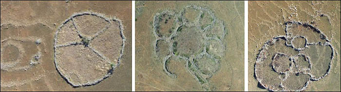
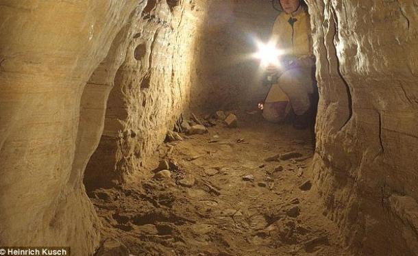
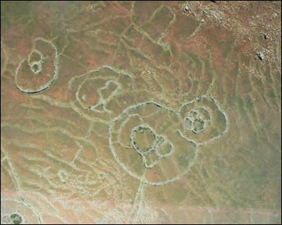
The individual ruins mostly consist of stone circles. Most have been buried in the sand and are only observable by satellite or aircraft. Some have been exposed when the changing climate has blown the sand away, revealing the walls and foundations.


They have always been there. People noticed them before. But no one could remember who made them -- or why? Until just recently, no one even knew how many there were. Now they are everywhere -- thousands -- no, hundreds of thousands of them! And the story they tell is the most important story of humanity. But it's one we might not be prepared to hear.

Something amazing has been discovered in an area of South Africa, about 150 miles inland, west of the port of Maputo. It is the remains of a huge metropolis that measures, in conservative estimates, about 1500 square miles. It's part of an even larger community that is about 10,000 square miles and appears to have been constructed -- are you ready -- from 160,000 to 200,000 BCE!

Ordering the Heavens: A Visual History of Mapping the Universe

Filo HArt's picture

by 

 Humanity’s long history of visual sensemaking is as much a source of timeless inspiration as a living record of how our collective understanding of the universe and our place in it evolved. It seems like the farther from the known mapmakers’ imaginations traveled, the more fascinating their maps became. And hardly does the unknown glimmer with more alluring sparkle than the cosmos. Explaining and Ordering the Heavens is a fantastic online exhibition fromThe Library of Congress, examining over 8 centuries of humanity’s evolving views of the universe, from ancient Buddhist cosmological maps to Galileo’s seminal work in astronomy to Persian celestial globes and more. Gathered here is a curated selection of images from the exhibition, alongside the original caption text accompanying them.

~Full Article~

Pages

Subscribe to RSS - history