Earth & Space Weather

Storm chasing from the sky

Magikalspirit's picture

Doyle Rice, USA Today-June 10,2013

(Photo: Robert Henson, NCAR)

Over the past few weeks, scientists in the central USA have been chasing severe storms from 7 miles above Earth, in a high-flying research jet that scans the skies for nascent severe storms.

Not all storm chasing is done on the ground.

Over the past few weeks, scientists in the central USA have been chasing severe storms from seven miles above the Earth, in a high-flying research jet that scans the skies for nascent severe storms.


Read More: http://www.usatoday.com/story/weather/2013/06/10/severe-weather-research-project/2409031

Post-Tropical Andrea To Impact United Kingdom

Magikalspirit's picture

msn weather update- June 9,2013


N/A


Andrea brought heavy rainfall to the northeastern United States Friday night into Saturday morning and then soaked Atlantic Canada Saturday into Sunday.

Andrea is now just a post-tropical low pressure, but its fast movement will allow it to reach Ireland and the United Kingdom by later Tuesday into Wednesday.


Read More: http://local.msn.com/WeatherArticle.aspx?cp-documentid=258313311

Tropical Storm Andrea zipping up the East Coast

Magikalspirit's picture

Jack Jones, Associated Press June 6,2013


This NOAA satellite image taken Friday, June 7, 2013 at 1:45 a.m. EDT shows expansive cloudiness across much of the eastern seaboard of the United States associated with Tropical Storm Andrea. Heavy rain showers and thunderstorms will move off to the northeast with this storm. Another frontal system over the Mid Atlantic and Ohio Valley into the Lower Mississippi Valley brings rain showers and scattered thunderstorms. |AP PHOTO | WEATHER UNDERGROUND|


COLUMBIA, S.C. (AP) After bringing rains, heavy winds and even tornadoes to parts of Florida, Tropical Storm Andrea moved quickly across south Georgia and was speeding through the Carolinas on Friday morning, promising sloppy commutes and waterlogged vacation getaways through the beginning of the weekend.

The first named storm of the Atlantic season lost some intensity after making landfall Thursday in Florida's Big Bend and its winds were down to 45 mph (75 kph) Friday.

~ Space Weather Update~ STORM WARNING:

Lia's picture

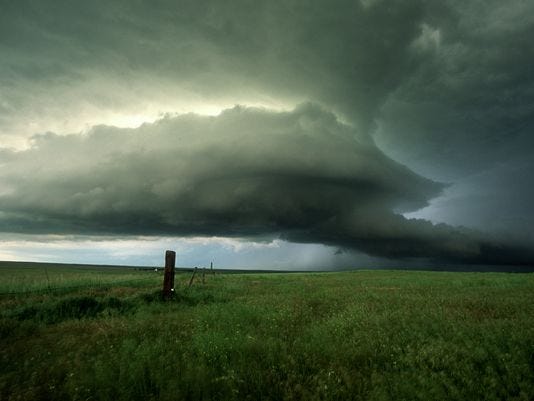
STORM WARNING: NOAA estimates a 60% chance of polar geomagnetic storms on June 9th when a CME is expected to deliver a glancing blow to Earth's magnetic field. High-latitude sky watchers should be alert for auroras. Aurora alerts: text, voice.


NOCTILUCENT CLOUDS: Researchers working with data from NASA's AIM spacecraft have announced that noctilucent clouds (NLCs) are behaving strangely. Boosted by changing "teleconnections" in Earth's atmosphere, the summertime clouds appeared earlier this year than ever before, setting the stage for an unusually good season of NLCs. "Unusually good" certainly describes the apparition this morning over Troon, Ayrshire, Scotland:

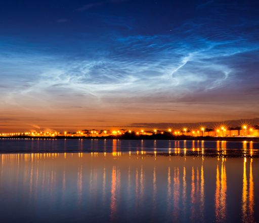
"It was an amazing display," says photographer Mark Ferrier. "The clouds appeared after sunset on June 8th and lasted straight through to sunrise on June 9th."

Small Asteroid Flying Between Earth and Moon

OdiStar's picture

NASA - June 8, 2013

This illustration shows the path of Asteroid 2013 LR6, which will pass within 65,000 miles (105,000 kilometers) of Earth on June 7 at 9:42 p.m. PDT (June 8 at 12:42 a.m. EDT). Image credit: NASA/JPL-Caltech


Small asteroid 2013 LR6 will safely fly past on June 7 at 9:42 p.m. PDT (June 8 at 12:42 a.m. EDT/June 8 at 04:42 UTC) at a distance of about 65,000 miles (105,000 kilometers) above Earth's surface.

The space rock, which is about 30 feet (10 meters) in diameter, will be above the Southern Ocean, south of Tasmania, at the time of closest approach.

Source:  NASA

Pages

Subscribe to RSS - Earth & Space Weather