Earth & Space Weather

~Space Weather Update~Solar Slinky~ Solar Wind Speed 444

Lia's picture

CHANCE OF STORMS: NOAA forecasters estimate a 15% chance of polar geomagnetic storms on August 17th in response to the possible impact of a minor CME. Arctic and Antarctic sky watchers should be alert for auroras. Storm alerts: text, phone.


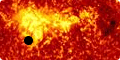
SOLAR SLINKY: Solar activity is low this week. Nevertheless, NASA's Solar Dynamics Observatory spotted something interesting happening on the sun's southwestern limb. Click to view the "solar slinky" in action:


The loops in the movie are made of magnetism, glowing red-hot because they are filled with 80,000 K solar plasma. They move with slinky-action as they are buffeted by winds in the sun's atmosphere and jostled by minor explosions on the stellar surface below. Of course they are much bigger than a terrestrial slinky. The entire Earth could fit through any of the loops with room to spare.


Realtime Space Weather Photo Gallery

July Hottest Month on Record in U.S.—Warming and Drought to Blame?

Rain's picture


GFP Note: Extreme weather events are generally seen as signs of Mother Earths' ascension process.


Christine Dell'Amore

National Geographic News

Published August 8, 2012

Heat picture - a construction worker cools off with a garden hose in Carpentersville, Illinois.

Construction-company owner Joe Weston cools off in Lake Geneva, Wisconsin, last month.

Photograph by Laura Stoecker, Daily Herald/AP

~Space Weather Update~ Quiet Sun Solar Wind Speed 451

Lia's picture


Thirty-five new items have just been added to our Meteorite Jewelry collection. Browse the Space Weather Store for something out of this world.


Meteorite jewelry


THE PERSEID METEOR SHOWER STILL UNDERWAY: Earth is passing through a stream of debris from Comet Swift-Tuttle, source of the annual Perseid meteor shower. Worldwide observers are now reporting more than 120 Perseids per hour. Forecasters recommend looking during the dark hours before dawn when activity is expected to be highest.

~Space Weather Update~ M Class Solar Flare~

Lia's picture

THE PERSEID METEOR SHOWER IS UNDERWAY: Earth is passing through a stream of debris from Comet Swift-Tuttle, source of the annual Perseid meteor shower. Worldwide observers are now reporting more than 90 Perseids per hour. Forecasters recommend looking during the dark hours before dawn, especially Sunday morning, August 12th, when activity is expected to be highest.


Realtime Perseid Photo Gallery

Got clouds? Tune into SpaceWeather Radio for live echoes from Perseid meteors flying over the US Space Surveillance Radar in Texas.


The multi-station Canadian Meteor Orbit Radar, sponsored by NASA's Meteoroid Environment Office, is also monitoring the Perseids. Live data are available here. Bright spots in this sample radar sky map show the radiants of currently active showers:


Unusual Summer Storm Blasts the Arctic

glr_Andrea's picture


Unusual Summer Storm Blasts the Arctic

Everett Rosenfeld
Time NewsFeed
Fri, 10 Aug 2012 
 
storm

A rare summer storm blasted the Arctic this week, beginning off the coast of Alaska, and moving over much of the Arctic Sea for several days before dissipating. 

Although the storm itself was uncommon - NASA's Goddard Space Flight Center in Greenbelt, Md., estimates that there have only been about eight similarly strong August storms in the last 34 years - the real news behind the meteorological event is the stunning Aug. 6 photo taken by the Moderate Resolution Imaging Spectroradiometer (MODIS) on NASA'sAqua satellite. The cyclone is spinning toward the North Pole, with Greenland visible in the bottom-left of the image. Scientists are left speculating what the impact of such a storm could be. 

From NASA:

Arctic storms such as this one can have a large impact on the sea ice, causing it to melt rapidly through many mechanisms, such as tearing off large swaths of ice and pushing them to warmer sites, churning the ice and making it slushier, or lifting warmer waters from the depths of the Arctic Ocean. 

Report: Drought worsens in key farm states

Rain's picture

Associated Press
By JIM SUHR,AP Business Writer

Aug 9, 5:34 PM EDT

A dry field of corn is seen near Ashland, Neb., Thursday, Aug. 9, 2012. The latest U.S. drought map shows that excessively dry conditions continue to worsen in the Midwest states that are key producers of corn and soybeans. This is the worst U.S. drought in decades. The weekly U.S. Drought Monitor map released Thursday, Aug. 9. 2012 shows that the area gripped by extreme or exceptional drought rose nearly 2 percent to 24.14 percent. (AP Photo/Nati Harnik

ST. LOUIS (AP) -- The Plains states where the production of corn and soybeans is key are being hit harder by excessive drought conditions in the wake of the hottest month on record in the continental U.S., contributing to a surge in global food prices.

~Space Weather Update~ Still Crackling with C Class Flares

Lia's picture


Hang the Transit of Venus on your wall! Hubble-quality images from NASA's Solar Dynamics Observatory are now available as metallic posters in the Space Weather Store.


Venus Transit metal posters


'METEOR SMOKE' LINKED TO NOCTILUCENT CLOUDS: A key ingredient of Earth's strangest clouds does not come from Earth. New data from NASA's AIM spacecraft shows that "meteor smoke" is essential to the formation of noctilucent clouds. [full story] [video]


Pages

Subscribe to RSS - Earth & Space Weather